
This is STOP 14, the 43rd, 44th and 45th days of our ten week cross country fall adventure in 2021! Here is a link to our previous stop in Rock Springs, WY.
The Drive from Rock Springs, WY to Torrey, UT

Rocks Springs Wy to Torrey UT
We have a 6.5 hour drive today and we got a later start than intended (that darn fun at karaoke last night). Once again, we head south on US 191 to Vernal where we stop for an early lunch at McDonald’s of all places. It is fun driving through Vernal since we stayed here for 2 days back in 2019 when we were exploring Dinosaur National Park. During lunch, Nancy contacts the bed and breakfast we will be staying at in Torrey to give them our arrival time only to learn they accidently cancelled our reservation! One of those odd computer glitches – they find our reservation payment, however the room we had picked (The Windgate Room) is taken. They only have one room left (The Arithmetic Suite) – and it will be ours for no extra charge and with multiple sincere apologies! After Vernal, we continue on US 191 through Duchesne. In Price, we turn on to UT 10 south to UT 72 south and look for the fairly new norther access point to the Cathedral Valley area just outside of Capital Reef National Park. We think we spot it, but aren’t sure. A few miles later, we turn east on UT 24 to Torrey. Sometime during today’s journey we cross the 7000 mile mark.


Torrey & The Torrey Schoolhouse Bed and Breakfast
Torrey is a very small town that exists to support tourism in Capital Reef National Park whose entrance is only 8 miles away. The town was settled in the 1880’s by the Mormons. We stayed here back in 2010 on our Utah adventure and we can see that the town has benefitted with some new lodging and restaurants. The B&B we stayed at last time isn’t in business any longer, so we choose to stay at the Torrey Schoolhouse B&B (that wasn’t in business that last time we were there). Located just 1.5 blocks off the main UT 24 through town, this bed and breakfast is housed in the 1914 school house and offers modern convenience and hot organic breakfast in a period setting. Each room has a school-themed name and there is even a “Teacher’s Lounge” that includes a full-size shared refrigerator/freezer, a microwave and sink.


Dinner at Rim Rock Patio
We head out to the Rock Garden Eatery & Bar located at the newer Red Sands Lodge, only to learn there is a private party and the restaurant isn’t open to the public tonight. They tell us to check with the front desk for other restaurants still open on a Sunday night and this late in the season. This area of UT shuts down at the end of October and it is the 24th of the month. Some restaurants have already closed for the season or have reduced their hours. We decide to head to the Rim Rock Patio – a small casual pizza place located at the Red Rock Inn. The place is busy and we get the last 2 seats in the entire place (fortunately at “the bar”) and meet our hostess & bartender, Ty as well as bar buddy Tasha. Our delicious pizza arrives – we eat half and save the other half for lunch tomorrow.


Day 2 – The Back Country Adventure to Bullfrog
As advertised, our day starts with a hot organic breakfast that consists of fresh cantaloupe, turkey sausage, a poached egg topped with cheese and an apple/oatmeal baked dish. We sit with a couple that has been here a few days and is about to leave.
We stop at the Capital Reef Visitors Center to get the latest information on road conditions before proceeding. The park ranger informs us that no one from the park service had been down that road in 3 days or so but the last reported road conditions were that there were no major issues.

Capital Reef Visitors Center
There is a main paved scenic drive near the Visitor Center, but we know from visiting the park before that you have to get into the back country to really see the best part of this region. Back in 2010 when we last visited the Capital Reef area we did a portion of the Notom-Bullfrog Backcountry Road but only as far as the cut over to Boulder. This time we want to complete the 68 mile road down to Bullfrog and Bullfrog Marina on Lake Powell that is run by the National Park Service in the Glen Canyon National Recreation Area. This first 15 miles of this road are paved but the middle 45 miles of the road is unpaved and can require 4 wheel dive depending on the weather. The last 10 miles near the marina are paved. The scenery is gorgeous, in fact we agree the best part is after that turn-off to Boulder (Burr Trail Rd).
Note the “check ferry schedule sign”.


We have lunch at a picnic area in Bullfrog. The water here in Lake Powell is SO low it is disheartening. We go to the ferry, that is closed – and we see the water is easily down 20 – 30 feet. The ferry hasn’t run in years as we look at where it used to dock. One of the campgrounds advertises “no lifeguards” but you can’t even see the beach and waters at this point. The boat ramp in the marina area is the only place that still touches water.


We head back to Capital Reef National Park the same way we came. It always amazes us how the same route can look so different when you travel it in the opposite direction.


Dinner at the Broken Spur
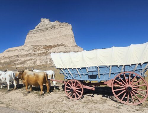
We go to a slightly more upscale restaurant tonight than last night – the Broken Spur Steakhouse. It is located at the Broken Spur Inn where you have the choice of staying in either a standard type room or glamping in a Conestoga wagon. Nancy orders the Ahi Tuna Steak and Harrison orders the Chicken Cordon Bleu – both are great choices. The theme outside of the restaurant is Halloween which includes a headless horseman!


Capital Reef National Park Scenic Drive
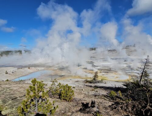
After another organic breakfast at our B&B, we start the day thinking we will sort of take it easy today – as the day unfolds, it couldn’t be further from the truth. Today will be all about re-exploring Capital Reef National Park. The park gets its named because of the white topped domes that resemble the US Capital and the reefs of the rocky cliffs that were a barrier to early travelers. The park is about 60 miles long by 6 miles wide and is focused around a 100 mile long geological feature named the Waterpocket Fold. Formed 50 to 70 million years ago when mountains were created along fault lines, this fold gets its Waterpocket name due to the many water eroded spaces (pockets) in the sandstone that expose so many cliffs, domes, spires, arches and canyons.
There is fresh snow on the mountains in the distance and we stop at one of the scenic overlooks of the park to get a few pictures before proceeding into the park.


We start out by driving the paved 7.9 mile scenic drive which passes by the historic Fruita, a town settled by Mormons in the 1880’s. All that remains is the restored schoolhouse, one home, a barn and orchards (the park maintains over 2500 trees in the orchard). We drive all the way to the end passing rocks with bands of differing thickness, colors, and textures lay one upon another like layers of a cake. We learn this was the original road through the area that was finally closed as a through road in 1964 when UT 24 was built.


At the end of the pave road is a 3-4 mile winding dirt road that leads to the Canyon Gorge Trailhead. We carefully drive down along sheer cliffs and towering walls, then proceed to hike into the gorge. We’ve done this hike before but it still offers wonderful sights. We both remark we need to learn more about the geology of this region. About 1.25 miles in, we pass by what is nicknamed “Pioneer Register” , a place where early travelers carve their name & year into the rock as proof of passage. We see an occasional petroglyph. We comment how these are all considered historical, but if anyone did either today, it would be vandalism and graffiti. We continue on into the gorge and back.


On our way back we take the other twisting dirt road into an area called the Great Wash. The landscape here is dramatically different. Unlike the red cliffs we’ve been driving through, this area is primarily yellowish and gray. There is a foot trail at the end, which we do not take, that leads to Cassidy’s Arch (named after Butch Cassidy who legend says also hid in this area).
The Cathedral Valley Backcountry Adventure
It is still fairly early – around 2:00pm so we decide to check out access to the Cathedral Valley area that we also drove into back in 2009. Here is a link to our post on that drive from 2009. There are 2 southern entrances from UT 24 that will take you up to the Cathedral Valley South Desert Overlook and a northern entrance that comes off UT 72 (that didn’t exist the last time we drove here). The recommended route is to drive the 56.7 mile loop by entering at the Fremont River (you drive IN the river for about 1/4 mile), driving clockwise around the loop and existing at the other southern entrance of UT 24 so you can see all the rock formations and beautiful scenery. The drive requires high clearance 4WD and take 6-8 hours. Since it recently rained, the Fremont River waters are much higher than normal and we choose NOT to drive in the river. And it is now 2:30pm, so we decide to take the other southern entrance and exit via the new northern entrance, thus only driving about 30 miles.
It takes us 2.5 hours to drive to the South Desert Overlook and the road was in worse condition than the last time we drove it. There were 3 places where we questioned whether we had enough clearance, but one of gets out of the truck to help the driver negotiate the dip. There were 2 other places where we had to carefully negotiate super narrow sections of the road as well as large rocks that had fallen into the road. The windy road up to South Desert Overlook and the Cathedral Spires is littered with rocks and it makes for a tricky drive.


As we get within 5 miles of the ascent up to South Desert Overlook, the road gets rough from washouts from the recent rain. There are boulders in the road along sections of the switchback that gets us up to the overlook where we have to squeeze by.


Finally we reach the top of the mesa and the view of South Desert Valley is spectacular! The wind is whipping up at the top, a few snowflakes are starting to fall, but the view is so rewarding.

South Desert Overlook – Cathedral Reef National Park
We now head toward the north entrance/exit which is only 11 more miles – 2/3 of which will be dirt and 1/3 will be paved. We are driving through a forest of tall pine trees and we are ready to get off this route.
With just 5 miles to go (one mile to the paved section) – we see a large pine tree that has fallen across the road, completely blocking our exit. REALLY? It is 5:30pm and we have between 2.5 and 3 hours to get back out the way we came – and the sun starts setting around 7pm. No sense wallowing in our fate – we turn around and head back out. Thank goodness for our 38 gallon gas tank – gas is not a worry – and at least we know the road conditions ahead of us.


We start back with the goal of getting past the trickiest areas before complete darkness sets in. This is a dark sky area and there’s a new moon (so no light from the moon tonight) so it gets REALLY dark. We do make great time and get past the worst of it, but we still have about 10 miles to go when in fact, it is pitch black. We get out and clean the headlights (we always carry glass cleaner and wipes) which makes a huge difference in our ability to see. But the standard headlights really aren’t enough for this type of driving. We have a flashlight in the car that Nancy holds out the window from time to time to assist, but it isn’t much of a help. NOTE: investigate improved lighting for the Brown Beast when we get home – and add a more powerful flashlight. We pass some folks who are camping for the night. About a mile later, we decide to just stop and marvel at the stars of the dark sky. Words and photos will not do justice to the planetarium worthy view we have of not only more stars than one can imagine, but the splendor of a clearly defined Milky Way.


It takes us even longer than anticipated to travel those final 10 miles on this poor condition dirt road in the dark, but we take our time. We finally exit around 8:40pm and have 20 miles back to town and our lodging. We still have no cell phone signal but we remember that most restaurants close at 9pm. As we get closer to town and get signal, we learn that the Rim Rock Patio is open until 9:30pm. We arrive just in time to order a carry-out pizza to take back to our room. We always have our backup supply of peanut butter, crackers, dried meats, canned peaches and chips – but the reward of a pizza after that adventure is exactly what we need. This wasn’t the “easy day” we thought we’d have today – but we have memories for a lifetime.
The next morning we share our story with our table companions as we enjoy a blueberry bread pudding and poached egg for breakfast.
Our Verdict
The Capital Reef area is truly one of our favorites and one we highly recommend. We have pretty much exhausted the hikes and drives the area has to offer between our two visits. While we may return some day, it won’t be on our must-do list for the near future. Even when we do come back this way, we probably will stay further south.
Next Up
Here is a link to our previous stop in Rock Springs, WY.
Our next stop will be 4 days in Page, Arizona. Well one day in St. George, UT and then 3 days in Page, AZ. We’ll explain why in our next post.
[…] This is STOP 15, the 46th, 47th, 48th and 49th days of our ten week cross country fall adventure in 2021! Here is a link to our previous stop in Torrey, UT. […]