Overview of the Oregon Road Trip Part One.
There have been times when we only had 2-3 weeks to travel. My Wife Nancy and I like to pick a state / area of North America and do what we jokingly call a “reconnaissance” trip where we spend our time moving rapidly from area to area. This gives us a good feel for what we might want to do when we come back and revisit an area at a slower pace someday.
This was our 3,248-mile 13-day road trip we did in Oregon in 2013 that covers a great deal of the state and really gave us a flavor for its diversity of geography and culture the state has to offer.
This is part 1 of a 2 part post. Click here to go to A Whirlwind 2 Week Oregon Road Trip Adventure Part 2

Oregon Road Trip Overview
Overnight Stopping Points
These stops are covered here in this post: “A Whirlwind 2 Week Oregon Road Trip Adventure Part 1”.
- B -Astoria
- C -Florence
- D– Diamond Lake
- E– Bend
- F – Burns
These stops are covered A Whirlwind 2 week Oregon Road Trip Adventure Part 2
- F – Burns
- I – Ontario
- K -Joesph
- L -Baker City
- M -Service Creek
- N -Portland
Day 1
We arrived in Portland, OR around 8:00 pm on 9/17. We selected our rental car and drove to Astoria arriving around 10:30 pm. With the 3 hour time difference – we were wiped tired and just settled into the Best Western and fell asleep.

Portland to Astoria OR
Day 2
Overview of the Day
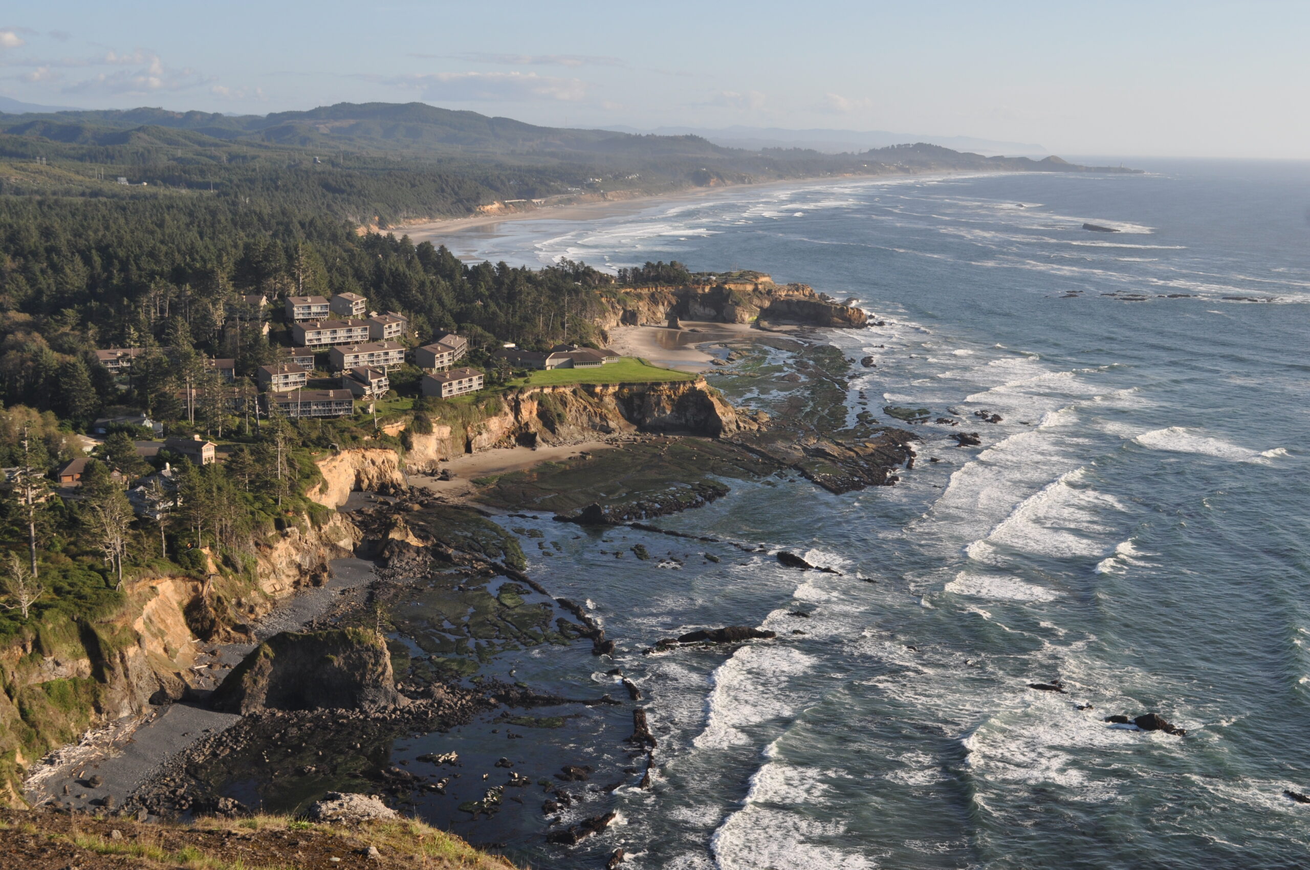
Today’s focus is the Pacific Coast from Astoria down to Florence. It’s going to be a really full day of sight-seeing and we get off to an early start at dawn. As you will see, this one day could easily be stretched into a week!

Astoria To Florence
Morning
We are used to getting up and getting ready for work at 5:30am east coast time. It’s hard to reset your body clock in one day when you first get to pacific time. We are up earlier than the hotel serves breakfast, so we take a walk around on a walking path behind the hotel along the Columbia River, watching the sun rise and then return to the hotel to eat.
Astoria
Astoria was founded as a fur trading outpost in 1811 as a part of Jacob Astor’s fur empire and is the oldest city in Oregon and the first American settlement west of the Rocky Mountains. Today it’s a port city of about 10,000 people. Before setting off on our adventure down the Oregon Coast, we do a short tour of the town to get a feel for it.
Goonies
We are both fans of the movie Goonies (1985). The film’s premise features a band of pre-teens who live in the “Goon Docks” neighborhood of Astoria, OR. While attempting to save their homes from demolition, they discover an old Spanish map that leads them on an adventure to unearth the long-lost fortune of One-Eyed Willie, a legendary 17th-century pirate. We decide to find the house and snap a few pictures.
Columbia River Maritime Museum
The acclaimed Columbia River Maritime Museum displays one of the most extensive collections of nautical artifacts on the west coast. This museum is one of the country’s finest displays about shipwrecks, lighthouses, fishing, navigation and naval history. We wanted to tour this museum, however, they didn’t open until later in the day and we had a full day ahead of us. We walk around the outside of it and will come back on another trip and go inside.
Astoria Column
Standing 600 feet above sea level, the Astoria Column offers a stunning 360° panoramic view of the mouth of the Columbia River. The column, which was dedicated on July 22,1926 is located atop Coxcomb Hill and displays a spiral of images of the natural resources and people who settled in this area. We ascend to the top of the column to survey the surroundings and the after a few pictures, we head to the gift shop. Our adventure down the coast is off to a great start!
Fort Clatsup
Fort Clatsup was the 1806 winter encampment of the Lewis and Clark Expedition. It features a reconstructed fort and a visitors center featuring tools and informational displays about the journey. This marked the end of their journey west before turning around and returning home.
Seaside Oregon
Our next stop after leaving Fort Clapson was to visit the little town of Seaside. This town is named after Seaside House, a historic summer resort built in the 1870s by railroad magnate Ben Holladay. It gave us a chance to walk down to the water and put our toes into the Pacific before heading south for the day.
Cannon Beach
Cannon Beach is famous for Haystack Rock, a 235 ft sea stack that juts out along the coast. A sea stack is a geological landform consisting of a steep vertical column or columns of rock in the sea near a coast, formed by wave erosion. The town got its name from a cannon that washed ashore in1896 from the US Navy schooner Shark. We park near the beach and walk down near the famous rock and get a few pictures. As we are driving out of town, we catch a glimpse of the whale sculpture which commemorates an encounter between the Lewis and Clark Expedition and the Tillamook tribe where the expedition barters for whale blubber.
Cape Meares
Our next stop was the Cape Meares Lighthouse which started operation on Jan 1, 1890. The views are really great and depending on the time of year the park service sponsors whale watching to help visitors spot whales. We note this as another must stop along the coast in our future.
Pelican Brewery
A short drive from the Cape Meares Lighthouse is Pelican Brewery which is located right on the beach in town named Pacific City. We had researched this place before our trip and talk about a wonderful setting for a Brew Pub! We are hungry and it’s lunch time so we stop for a bite and relax.
Depoe Bay
As we pass through the small city of Depoe Bay, we little notice a whale sculpture and decide to pull in and admire the scenery. We learn this town considers themselves the whale watching capital of the Oregon Coast. In addition, it also claims to be the world’s smallest navigable harbor at 6 acres and connects directly to the Pacific Ocean.
Cape Foulweather
Cape Foulweather is an outcrop that rises 500 feet above the Pacific and is notable as the first land to be sighted and named by Captain James Cook in March 1778. Cook was on his third voyage around the world. He gave the name ‘Foulweather’ to this area because of the fierce weather he encountered in this area. The path up to the viewpoint contains the visitors center and a fairly large gift shop.
Devil’s Punchbowl State Park
Devil’s Punchbowl State Park is named for a large hollow rock formation bowl that was naturally carved in a rock headland partially open to the Pacific Ocean. Waves enter the bowl and often violently churn, swirl, and foam during high tide. During the 1930’s the Civilian Conservation Corps developed day use improvements for the park, including picnic tables, restrooms, fountains, water supply, fireplaces, a foot trail and steps to the beach. Unfortunately, it isn’t high tide while we are there, so we don’t get to appreciate its full beauty.
Rogue Brewery
Not far down the road in Newport, we stop off at Rogue Brewery and have dinner along the waterfront and watch the sun set over the Pacific Ocean.
Florence
Our hotel is just up the road at the Landmark Inn and when arrive its dark out. We settle in quickly, relax, and reflect on what a great, ambitious day it has been. We definitely need to come back to Florence to experience all the town has to offer.
Day 3
Starting from Florence we will retrace our route a short distance and go see the Heceta Head Lighthouse, visit the Sea Lion Caves and then proceed down the coast to Coos Bay before heading in land. Our final destination of the day is Diamond Lake where we will a short distance from Crater Lake National Park which will be the primary focus of day 4. 
Florence To Diamond Lake Oregon
Florence Morning Walk
After breakfast we stroll down to the downtown waterfront to get a feel for this little town. We were definitely left with the impression that we need to return to this town someday and spend more time here.
Heceta Head Lighthouse
The Heceta Head Lighthouse is touted as one of the most photographed lighthouses on the Pacific Coast. We have a really full day planned and get a few photos at a distance from the Sea Lion Caves. The next time we are in this area, we are going to need to go down and visit the lighthouse up close.
Sea Lion Caves
The Sea Lion Caves have been a tourist attraction since 1932 along the Pacific Coast Highway. To enjoy it, you take an elevator down to a sea cave where you view sea lions. Our timing was poor however and we only saw one seal lion sitting on a rock and andother out swimming in the ocean. It would have been a lot more fun if the caves had been active but we still got a kick out of the experience and doing the ‘tourist’ thing.
Heading South to Coos Bay
As we head south, we start to see evidence of the Oregon timber industry. Before we can reach Coos Bay we stop to admire the Coos Bay Bridge and then cross it and enter Coos Bay. The population of this port city is about 16,000 and as recently as 2017, 1.7 million tons of timber and pulp shipped from this port. As we pass through the downtown, we catch a glimpse of ships loading timber in the harbor.
Shopping for Myrtlewood
As we leave Coos Bay,we stop and do a little shopping. Before our trip, Nancy had read about Myrtlewood which is a broadleaf evergreen that only grows in Southwestern OR and Northwestern CA. The store we stopped at had a large selection of products made of this wood and we ended up buying several items. The big fat cat in the store was also entertaining while we were there.
East to Roseburg
From Coos Bay we now start heading east to Roseburg on our way to Diamond Lake. As we begin this leg of the journey, we start to travel through timber and farm country.
Roseburg
We had read about McMenamins, which is brew company that buys historic properties and converts them into pubs. Over 31 years, they now have over 50 different locations across Oregan and Washington. On this trip we had put several of these on our lists as places we were going to visit.
The first stop on this list was for lunch in Roseburg at McMenamin’s Station Pub & Brewery. This establishment is housed in what was once the city’s bustling Southern Pacific train depot. The ambience of the old rail station doesn’t disappoint and we even get to do a little of one of our favorite activities which is meeting and talking with locals.
Colliding Rivers
The Colliding Rivers is the name given to where the Little River merges into the North Umpqua River at Glide, OR, about 12 miles east of Roseburg. The reason it is known as Colliding Rivers is because the two rivers almost meet head on. It was a good place to stop, relax and just wander around the rivers for a bit.
Tioga Bridge
Shortly after we leave Colliding Rivers, we see an interesting foot bridge and decided to stop and take a look. It turns out it’s called Tioga Bridge and was rebuilt as a foot bridge from the piers of a bridge that washed out in 1964 (part of the original highway). It now serves as the trail head now to the North Umpqua Trail. We cross the bridge and hang out in the area for a short period of time and then decide it’s time for us to move on to our next activity of the day.
Toketee Falls
Toketee Falls is one of the most famous waterfalls in Oregon, renowned for the columnar basalt formation framing the two-stepped falls. The Umpqua River has carved a gorge out of the lava flow, resulting in a waterfall of 113 feet in height with a 28 foot upper tier which plunges into a pool followed by an 85 foot plunge into a larger pool. Near area we also see a large water pipe but there is no indication where this water is being shipped to.
Diamond Lake
Diamond Lake Resort has evolved from a small fishing lodge built in the 1920s, to a modern family resort that is a wonderful place to take in the beauty of nature and Crater Lake National Park.
We had dinner at the Lodge and ended up having a great time with bartender Bruce and father/son locals Nick and Dave.
Day 4
From Diamond Lake we are going to head to Crater Lake National Park and then proceed to our next overnight destination of Bend, OR. Our plan today is to spend the bulk of the day at Crater Lake and then get to Bend in time for the Octoberfest Festival which will be going on in the evening.

Diamond Lake to Crater Lake to Bend OR
Crater Lake
Crater Lake National Park has inspired people with its beauty for thousands of years. It was formed when the 12,000 foot Mount Mazama volcano erupted and then collapsed.
With a depth of 1,943 feet, this makes it the deepest lake in the United States, and the ninth deepest in the world. There are no rivers flowing into or out of the lake. The evaporation is compensated for by rain and snowfall at a rate such that the total amount of water is replaced every 250 years. In 1902, it was designated as a national park. We spent most of the day here driving the scenic road around the lake and hiking on trails.
Bend
Bend is a city of about 100,000 people and we are going to use it as an anchor to explore a number of the regional outdoor attractions. We are staying in a boutique hotel suite near the downtown area within easy walking distance of restaurants and the local Octoberfest we read about in our research of the area. It’s in quiet neighborhood across from a church and only a couple blocks off the main street. This is one case where pre-planning was essential. If one were just free-style traveling and didn’t know about this once a year festival, finding lodging last minute would have been impossible. Planning tip – check for festivals in the area you plan to travel to! You may want to avoid an area or you may want to modify plans to ensure you can attend.
Octoberfest
After settling into our suite, we head out for Octoberfest and find a lively crowd of revelers. As usual it doesn’t take us long to hook into and hang out with a bunch of the locals. As a part of the admission to the festival we get a couple of beer steins to mark the occasion. After a few hours of great conversation, it’s getting late and we head out to dinner at McMenamins St Francis School Pub which is the next McMenamins property on our list.
McMenamins St Francis School Pub
The Old St. Francis School was bult in 1936 as a Catholic school. In 2004 It was converted into a hotel, theater and pub. The atmosphere was great and the food was decent. We would recommend this as stop if you are ever in Bend.
Day 5
Overview
Today’s main adventure is divided into the two parts. First we are going to go on the McKenzie Pass – Santiam Pass Scenic Byway Loop to enjoy Deer Creek Hot Springs and explore some of the lava fields in the area at the Dee Wright Observatory. The Byway boasts the highest concentration of snowcapped volcanoes in the lower 48 states. Second, we are going to head south of Bend to Newberry Crater to view another collection of volcanic activity.

Day 4 Adventuring from Bend
Sisters
Our route takes us through the town of Sisters – which looks like it hosts some interesting breweries & restaurants. The Santiam Highway and McKenzie Highway merge briefly to form Cascade Avenue, the main thoroughfare through downtown Sisters.
McKenzie and Santaim Pass Scenic Byway Map

Mckenzie and Santiam Scenic Byway
Sisters through Santiam Pass
Deer Creek Hot Springs
The Deer Creek Hot Springs (aka Bigelow Hot Springs) are tucked in the bank right alongside the roaring McKenzie River at an elevation of 1800 feet. It is unmarked and about a 1/4 mile hike from where we park the car by the bridge. The pool measures 8 by 13 feet, is 1 to 2 feet deep, is 104 degrees F, and is floored with coarse sand. We hike down the path along the river and strip down to our undies and jump in!
McKenzie Pass
After a great soak in the hot springs, we pick the loop back up and head toward McKenzie Pass.
Pioneer Mailman
Near the top of McKenzie Pass we stop and go the grave of the “Pioneer Mailman” who died in a snowstorm on his way to deliver mail. People leave money & trinkets at this site where his body was found.
Dee Wright Observatory
The observation tower is built out of the same igneous rock that covers the surrounding area. The viewing windows are cut to specifically highlight the neighboring mountains. These “lava tube” viewing holes allow visitors to easily identify the different Cascade peaks. The Dee Wright Observatory was built during the Great Depression and was completed in 1935.
After visiting the observatory, we head back to Sisters to for lunch.
Three Creeks Brewpub
In sisters, we stop at Three Creeks Brewery for lunch. After a really active morning we are starved and are delighted with the quality of the food and beverage. With our bellies now full it’s time to head out to the second half of adventure today.
Newberry Crater and Lave Butte
Newberry Caldera has existed as long as 500,000 years, when the cone of the volcano is thought to have first collapsed. Subsequent caldera-forming collapses have further deepened the caldera but volcanic material and lake-bed sediments have largely filled in much of this depth. Lave Butte rises about 500 feet above the visitor’s center and offers up some great views of the area.
Big Obsidian Flow Loop Hike
One of the features of the Newberry volcanic area is the Big Obsidian Flow. Obsidian is a hard, dark, glass that is formed by magma that cools rapidly. It is a short drive south of the Lava Butte visitors center to the Big Obsidian Flow Loop Trail which takes you directly into this marvel of nature. It’s a short .8 mile trail that is fairly easy to transverse. The Big Obsidian Flow is a patch of black and grey volcanic glass covering about 4 square miles of the Newberry Crater floor. You can expect to see everything from the classic jet-black glass suited for Native American tools to frothy grey glass that looks more like a stone sponge than an arrowhead.
Back to Bend and Dinner at Deschutes Brewery
It’s dark by the time we get back to the hotel and we head out for dinner at Deschutes Brewery Public House. As we head towards the restaurant, we pass the Octoberfest Festival which is going strong again. After dinner, it’s time to rest up and get ready for another day of adventure.
Day 6
Overview
This is the longest one-day adventure of the entire trip – we will be winding through the Oregon Outback. This term “Oregon Outback” references a fairly large area of high desert and range country in the south-central portion of Oregon. A great deal of this land is managed by the Bureau of Land Management and has several protected areas to visit which include the Hart Mountain National Antelope Refuge and the Warner Wetlands.

Oregon Outback
Oregon Outback
We take a short drive south of Bend and find a sign marking the turnoff to the Oregon Outback. It’s overcast this morning as we setoff but at least it’s not raining. It isn’t long before we break through the last remnants of the Deschutes National Forest and start to encounter high plains desert.
Fort Rock and the Fort Rock Homestead Museum
The first stop on our adventure is Fort Rock which is a natural feature that rises up over the flatness of this region. It was once an Island back when this area was an inland sea. Before reaching this, we pass by the Fort Rock Homestead Museum which is a collection of homestead buildings that have been collected from the surrounding area. Unfortunately for us its closed but from the road we at least get a glimpse of it. At Fort Rock, we stop and hike for a bit in and around this feature before moving on.
Oregon Outback
As we travel the Outback we see a land that spreads out far across the valley. We see a number of cattle operations and pass through a handful of really small towns.
Warner Wetlands
Out next destination is the Warner Wetlands, an area composed of a large 40-mile chain of lakes separated by a series of dunes. We stop at the Interpretive Center to have lunch at the picnic area, walk around and stretch our legs.
Warner Valley Overlook
To get to our next destination, the Hart Mountain National Antelope Refuge, we have to climb a series of switchbacks to get to the beginning of the road we need to travel on. At the top we find a short trail to an overlook that provides a sweeping view of the Warner Valley.
Hart Mountain National Antelope Refuge
Hart Mountain National Antelope Refuge is located on a massive fault block ridge that ascends abruptly nearly 3/4 of a mile above the Warner Valley floor in a series of rugged cliffs, steep slopes, and knife-like ridges. We experience spectacular views of the beautiful Warner Valley Wetlands while ascending the west side entrance road to the refuge headquarters. The west face of the mountain is cut by several deep gorges. The east side of the mountain is less precipitous, descending in a series of rolling hills and low ridges to the sagebrush-grasslands typical of southeastern Oregon and the Great Basin.
The Antelope Refuge to Burns Oregon
When we get to the end of the gravel road through the Antelope Refuge, we turn left on Oregon 205 and head for Burns. This is a sparsely populated but very scenic area of Oregon. There is only the small village of Frenchglen which has the old Frenchglen Hotel and cattle ranches. As we near Burns we pass through a small portion of the Malheur National Wildlife Refuge and pass along the large lake that is part of the refuge.
Burns Oregon
The small town of Burns has a population of about 2,500 and sets just north of the area we are going to be exploring next. We get to our room at the America’s Best Inn and settle in for the night.
Click here to continue to A Whirlwind 2 week Oregon Road Trip Adventure Part 2


Leave a Reply